
ABot-Earth 0.5 – Amap's World's First 3D-Native Urban World Model
Executive Summary:
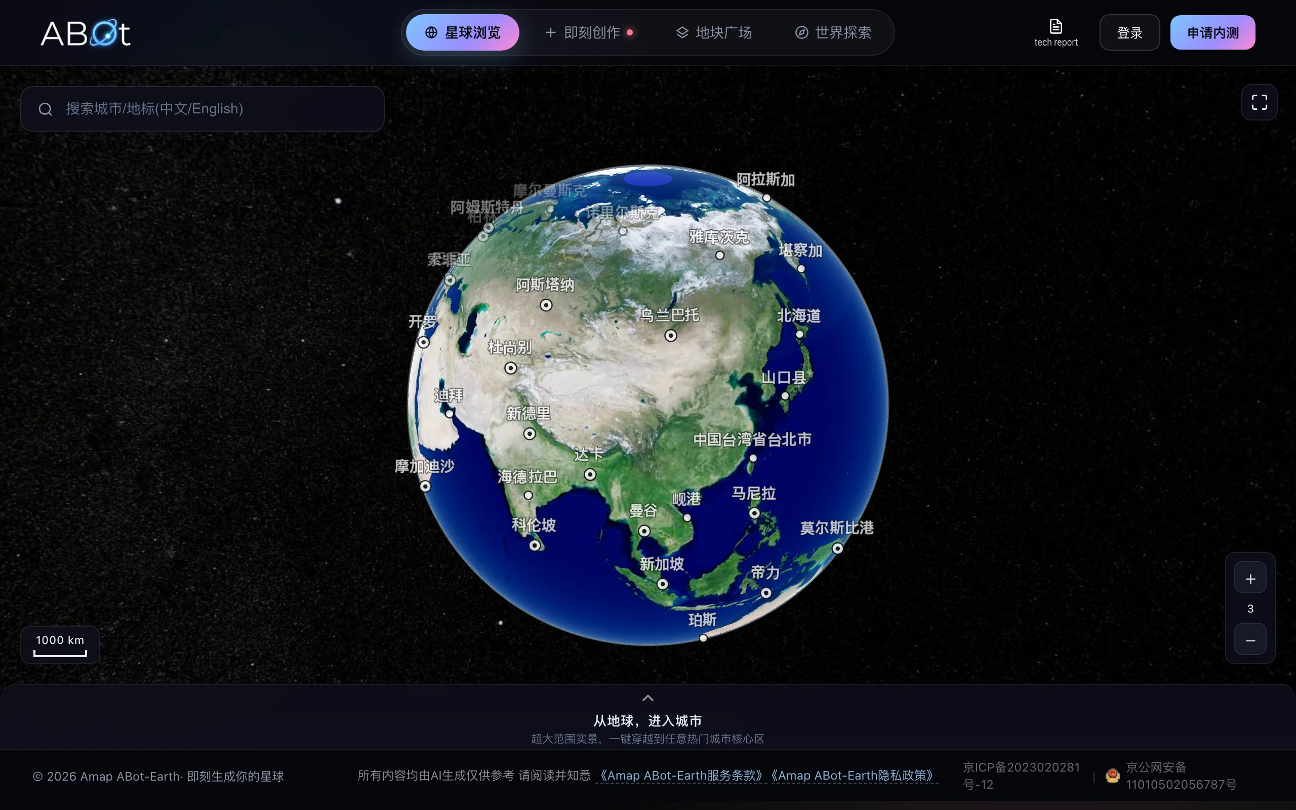
ABot-Earth 0.5 is the world's first 3D-native urban world model from Amap, part of Alibaba Group. Positioned as an automated 3D city factory, it lets users input a single satellite image or a text des...
1. What Is ABot-Earth 0.5
ABot-Earth 0.5 is the world's first 3D-native urban world model from Amap, part of Alibaba Group. Positioned as an automated 3D city factory, it lets users input a single satellite image or a text description and generate kilometer-scale, high-precision 3D city scenes on consumer GPUs in about 10 minutes. Output is editable 3D Gaussian Splatting (3DGS) assets that can be imported directly into Unity, Unreal Engine, and other mainstream engines. This breakthrough compresses traditional manual modeling workflows that take days or weeks into minutes, cuts cost to roughly 1% of conventional methods, and redefines both the efficiency and accessibility of city-scale 3D content production.
Image source: Official article
Technical positioning and domain: It sits at the intersection of computer vision and generative AI, focused on automated reconstruction and generation of large-scale 3D urban scenes. Its distinctive positioning is "3D-native": it outputs editable 3DGS representations directly, rather than relying on indirect 2D-to-3D conversion, enabling an end-to-end pipeline from satellite imagery or text to 3D assets.
Development background: Built by Amap's CVLab team within Alibaba Group, the project draws on Amap's deep expertise in map data, satellite imagery, and geospatial processing. The team has long worked on large-scale 3D map construction. ABot-Earth 0.5 targets the high cost, long cycle times, and dependence on professional equipment in traditional 3D city modeling, aiming to democratize 3D generation.
Core value: It addresses three core pain points in high-precision 3D city content production: cost (about 1% of traditional methods), efficiency (roughly 1000× faster), and accessibility (runnable on consumer GPUs). It gives game development, embodied AI, low-altitude economy, film production, and related fields unprecedented rapid 3D city generation, making "generate any city on demand" a practical reality.
Technical characteristics: It uses 3D Gaussian Splatting as the core representation, combined with generative AI for end-to-end reconstruction that infers 3D structure, building height, and texture from a single 2D image or text prompt. The system builds a fully automated factory pipeline and applies deep inference optimization for consumer GPUs, achieving roughly 1000× acceleration.
2. Key Features
Single-image/text 3D city generation: Users only need one satellite image or a text description (e.g., "Shibuya Crossing, Tokyo"). The system parses geographic and architectural semantics and generates the corresponding kilometer-scale 3D city scene, converting 2D input directly into 3D assets without multi-view images or depth data.
Minute-scale efficient reconstruction: On consumer GPUs such as NVIDIA RTX 3060, the system completes automatic city-scale reconstruction and rendering in about 10 minutes. Compared with photogrammetry or manual modeling cycles of days to weeks, efficiency improves by roughly 1000×, greatly shortening project iteration time.
3DGS format output: The model natively outputs standard 3D Gaussian Splatting assets, preserving geometry, texture, and semantic information. 3DGS supports real-time rendering, editability, import into mainstream engines, and file sizes far smaller than traditional mesh models, making secondary development and reuse easier.
Seamless engine integration: Generated 3D assets can be imported directly into Unity, Unreal Engine, and other mainstream game engines and visualization platforms for plug-and-play use. Developers avoid format conversion and manual adjustment, lowering the barrier from generation to application.
Global coverage: A 3D map dataset covering 190+ countries and regions supports 3D city generation for terrains worldwide. For any region's satellite image or place name, the system can produce reasonable 3D scenes from existing data or generative inference.
Automated factory pipeline: A fully automated data processing and generation pipeline runs from input parsing through 3D reconstruction to asset export with no human intervention. The system handles satellite distortion, lighting variation, occlusion, and related issues to keep output quality consistent.
Lightweight inference optimization: Model compression, operator fusion, and parallel compute acceleration for consumer GPUs greatly reduce memory and compute requirements. City-scale 3D reconstruction no longer depends on expensive render farms; ordinary developers can run it locally.
3. How to Use
Apply for closed beta access: Visit https://abot-earth.amap.com/, click "Apply for Beta" in the top-right corner, fill in relevant information (use case, intended purpose, etc.), and submit for review. Review usually takes 1–3 business days; approved users receive login credentials.
Log in to ABot-Earth Studio: After approval, sign in to the ABot-Earth Studio console. The console provides project management, generation tasks, asset downloads, and other core features. First-time users should read the quick-start documentation.
Create a scene project: In the console, click "New Scene" and choose generation mode: "Image Generation" or "Text Generation." For image mode, upload a clear satellite image (recommended resolution at least 1024×1024, JPEG or PNG). For text mode, enter a target city description (e.g., "Lujiazui financial district, Shanghai, with Oriental Pearl Tower and skyscrapers").
Configure generation parameters (optional): The system parses input and sets defaults automatically, but advanced users can adjust generation area (default 1 km × 1 km, up to 5 km × 5 km), building detail level (LOD0–LOD3), and output format (currently 3DGS only; more formats may follow). Beginners should keep defaults on first use.
Submit and wait for generation: After confirming parameters, click "Generate." The task is sent to the cloud inference cluster. Progress is visible in the task list in real time; average runtime is about 10 minutes. You can close the page; email notification is sent when complete.
Download assets: When generation finishes, click "Download" on the task detail page to get standard 3DGS files, usually a compressed package with point cloud data, texture maps, and scene metadata. After extraction, import directly into Unity (3DGS plugin required), Unreal Engine (via plugin), or Blender (via plugin).
Notes: During beta, daily generation is limited (typically 5 runs). Start with text mode on small scenes for testing. Avoid heavy cloud cover or severe distortion in satellite images, which can hurt quality. Generated 3DGS assets cannot be used directly for commercial release without following Amap's terms of use.
4. Pros and Cons
| Pros |
|---|
| Cost disruption: 3D city mapping costs about 1% of traditional manual modeling, turning high-precision 3D generation from a heavy asset into a lightweight tool and lowering the barrier for small and mid-sized teams. |
| 1000× efficiency: A kilometer-scale scene can be generated in about 10 minutes on a consumer GPU, roughly 1000× faster than traditional workflows, greatly accelerating iteration. |
| Very low barrier: No render farm or workstation required; ordinary consumer GPUs (e.g., RTX 3060) are enough, cutting hardware investment sharply. |
| Global coverage: A 3D map dataset spanning 190+ countries and regions is among the broadest city-scale 3D coverage available, enabling generation for almost any location. |
| Plug-and-play: Generated 3DGS assets import directly into Unity, Unreal Engine, and other mainstream engines without format conversion, enabling fast integration into existing projects. |
5. Comparison with Similar Tools
| Dimension | ABot-Earth 0.5 | Google Earth Studio |
|---|---|---|
| Generation method | AI single-image/text direct 3D scene generation | Browse existing satellite data; not generative |
| Generation speed | ~10 minutes (kilometer scale) | Real-time browsing (no generation step) |
| Hardware requirements | Consumer GPU (RTX 3060 or better) | Browser only (cloud rendering) |
| Output format | 3DGS (editable, engine-importable) | Not editable (video/image export only) |
| Coverage | 190+ countries/regions (auto-generated) | Global (satellite browsing only) |
| Cost | ~1% of traditional (free in beta) | Free browsing; paid API (~$0.01/frame) |
| Ease of use | Very low (input and generate) | Medium (learn browsing workflow) |
Selection advice:
- Rapid prototyping and game development: For fast city base maps in game levels or virtual production, ABot-Earth 0.5 is the top choice. Minute-scale generation and low barriers let non-specialist 3D artists obtain editable assets quickly, while CityEngine's rule-based modeling is precise but steep and slow.
- GIS and urban planning: For professional GIS needing precise coordinates, building height layers, and semantic tags, Esri CityEngine still excels through parametric modeling on real geographic data and deep ArcGIS integration. ABot-Earth 0.5 is more visual today; geospatial precision still needs validation.
- Presentation and visualization: Google Earth Studio suits quick flythrough videos from real satellite imagery with no generation step, but cannot export editable 3D models. ABot-Earth 0.5 is stronger when interactive 3D scenes are required.
6. Editor's Take
ABot-Earth 0.5 marks a paradigm shift in 3D city generation. Technically, its core innovation combines 3D Gaussian Splatting with generative end-to-end reconstruction and extreme optimization for consumer GPUs, achieving the triple breakthrough of "10 minutes, consumer GPU, kilometer-scale scene." Compared with traditional NeRF methods that need multi-view images and render slowly, 3DGS editability and real-time rendering are closer to industrial use. Amap's work on model compression and inference acceleration (roughly 1000× efficiency gain) stands out as engineering depth, not just algorithmic novelty.
In practical terms, ABot-Earth 0.5 directly serves urgent demand for massive 3D city assets in game development, film previsualization, and embodied AI simulation. Traditionally, an open-world city base map might take an art team months; ABot-Earth 0.5 can compress that to hours at about 99% lower cost. For small and mid-sized teams, it is a disruptive productivity tool.
The audience is clear: game developers, VFX artists, robotics/autonomous driving simulation engineers, and urban planners needing macro visualization. Closed beta limits large-scale use today, but the official release could become an industry default.
Future potential is large: indoor scenes, terrain generation, integration with Amap navigation and POI data for semantic digital twins, and multimodal input (video, point clouds) with streaming generation.
Rationale: Extremely high technical innovation (3D-native + 1000× acceleration) and strong practical value, but closed beta and single output format cost half a star. The official release should open more features and APIs.
7. Use Cases
Game development: Quickly generate open-world 3D city base maps. Upload a satellite image or text description and get an editable 3DGS scene in about 10 minutes for direct import into Unity as level background, cutting art asset cost, especially for early open-world prototyping.
Embodied AI simulation: Provide high-precision 3D city training data and simulation environments for robotics and autonomous driving. Researchers can generate multiple cities for environment generalization in RL without field collection, with randomized layouts for robustness.
Low-altitude economy: Build 3D digital base maps for drone route planning and airspace management. Operators input satellite imagery and quickly get scenes with building height and terrain for obstacle avoidance simulation and airspace visualization, improving approval efficiency.
Emergency response: Restore disaster-site 3D environments in minutes. After floods or earthquakes, input latest satellite imagery to generate 3D scenes for situational assessment, rescue routing, and resource dispatch.
Film production: Quickly generate digital twin city backgrounds. Directors or VFX teams describe a scene (e.g., "cyberpunk future Tokyo block") and get 3D background for virtual production or compositing, shortening pre-production.
8. FAQ
Q: Is ABot-Earth 0.5 completely free?
A: Free during closed beta, with limited daily generations (typically 5). Pricing after official launch may be usage-based or subscription; details are not announced yet.
Q: What hardware do I need?
A: Generation runs in the cloud; a browser is enough to submit tasks. For local 3DGS rendering, use at least NVIDIA RTX 3060 (6 GB VRAM) or equivalent AMD GPU.
Q: How precise are generated cities? Can I see windows and signs?
A: Kilometer-scale precision is enough for building outlines, road networks, and block layout, but micro detail like individual windows or signs cannot match hand modeling. Good for macro display and game base maps, not close-ups.
Q: Can I use generated 3D assets commercially?
A: Beta assets are for evaluation and testing only; commercial use requires official licensing terms from Amap.
Q: Why do some buildings look deformed or textures blurry?
A: Common causes: low-resolution satellite input, cloud cover, uneven lighting, or overly abstract text prompts. Use high-resolution satellite images and specific text (architectural style, height range, etc.).
Q: Does it support batch generation or API calls?
A: Closed beta supports Web console only, not batch or API. Amap plans REST API in the official release for programmatic use.
9. Project Links
- Official site: https://abot-earth.amap.com/
- Technical report: https://github.com/amap-cvlab/ABot-Earth-0.5/blob/main/tech-report.pdf
- GitHub (examples and docs): https://github.com/amap-cvlab/ABot-Earth-0.5
Related AI Model Articles
In-Depth Review of Longcat-2.5-preview: Meituan's Next-Generation Multimodal Long-Range Agent Model
LongCat-2.5-preview is Meituan's latest next-generation large model. Building upon the 1.6T total parameters, approximately 48B active parameters, and native 1M token context of LongCat-2.0, it marks ...
Xiaomi MiMo-V2.6 – Xiaomi's Open-Source Multimodal Model Series
Xiaomi MiMo-V2.6 is a series of fully multimodal models released and open-sourced by Xiaomi, comprising two native full-modal models: Pro and Flash. It is centered on large-scale Agentic reinforcement...
In-Depth Review of Step 5 Preview: A 600B Sparse MoE Flagship with 1M Token Context and 1/8 Cost Advantage
Step 5 Preview is a new-generation flagship foundation model launched by StepFun, designed for real-world Agentic tasks. Based on a sparse MoE architecture, the model has a total of 600B parameters bu...

Qwen3.8-Omni-Flash – A Native Multimodal Model Launched by Alibaba Qwen
Qwen3.8-Omni-Flash is a native multimodal model launched by Alibaba Qwen. It jointly models four modalities—text, image, audio, and video—within a single architecture, supporting a context length of u...
© All Rights Reserved. Some content on this site is partially generated by AI with human review.